
This list of Frequently Asked Questions (FAQ) has been compiled from questions asked of the SPC as well as basic tornado research information and countless scientific resources. More material will be added, time permitting. If you find a link not working or an error of any sort, please e-mail the FAQ author.
The Tornado FAQ is not intended to be a comprehensive guide to tornadoes. Instead, it is a quick-reference summary of tornado knowledge, which will link you to more detailed information if you desire. Recent books from your local library or a major university library are still the deepest resource for learning about tornadoes and other severe storms; so if you are doing your own research or school reports, please visit the library in person. There are many good websites with tornado information also. Some of them are linked from the answers below. None of the links to outside websites implies any kind of commercial endorsement on the part of the SPC. The intent here is to direct you to the best tornado info available. There is also a partial list of technical scientific references related to tornadoes for those with some meteorological education and training.
NOTE: All images found in FAQ pages on this site must be public domain and not copyrighted. However, credit MUST be given to National Oceanic and Atmospheric Administration/Department of Commerce unless instructed to give credit to the photographer or other source. Complete Tornado FAQ content is found at the mirror-backup site.
 What is a tornado? According to the Glossary of Meteorology (AMS 2000), a tornado is "a violently rotating column of air, pendant from a cumuliform cloud or underneath a cumuliform cloud, and often (but not always) visible as a funnel cloud." Literally, in order for a vortex to be classified as a tornado, it must be in contact with the ground and the cloud base. Weather scientists haven't found it so simple in practice, however, to classify and define tornadoes. For example, the difference is unclear between an strong mesocyclone (parent thunderstorm circulation) on the ground, and a large, weak tornado. There is also disagreement as to whether separate touchdowns of the same funnel constitute separate tornadoes. It is well-known that a tornado may not have a visible funnel. Also, at what wind speed of the cloud-to-ground vortex does a tornado begin? How close must two or more different tornadic circulations become to qualify as a one multiple-vortex tornado, instead of separate tornadoes? There are no firm answers.
 BACK UP TO THE TOP
How do tornadoes form? The classic answer -- "warm moist Gulf air meets cold Canadian air and dry air from the Rockies" -- is a gross oversimplification. Many thunderstorms form under those conditions (near warm fronts, cold fronts and drylines respectively), which never even come close to producing tornadoes. Even when the large-scale environment is extremely favorable for tornadic thunderstorms, as in an SPC "High Risk" outlook, not every thunderstorm spawns a tornado. The truth is that we don't fully understand. The most destructive and deadly tornadoes occur from supercells -- which are rotating thunderstorms with a well-defined radar circulation called a mesocyclone. [Supercells can also produce damaging hail, severe non-tornadic winds, unusually frequent lightning, and flash floods.] Tornado formation is believed to be dictated mainly by things which happen on the storm scale, in and around the mesocyclone. Recent theories and results from the VORTEX program suggest that once a mesocyclone is underway, tornado development is related to the temperature differences across the edge of downdraft air wrapping around the mesocyclone (the occlusion downdraft). Mathematical modeling studies of tornado formation also indicate that it can happen without such temperature patterns; and in fact, very little temperature variation was observed near some of the most destructive tornadoes in history on 3 May 1999. The details behind these theories are given in several of the Scientific References accompanying this FAQ. BACK UP TO THE TOP
What direction do tornadoes come from? Does the region of the US play a role in path direction? Tornadoes can appear from any direction. Most move from southwest to northeast, or west to east. Some tornadoes have changed direction amid path, or even backtracked. [A tornado can double back suddenly, for example, when its bottom is hit by outflow winds from a thunderstorm's core.] Some areas of the US tend to have more paths from a specific direction, such as northwest in Minnesota or southeast in coastal south Texas. This is because of an increased frequency of certain tornado-producing weather patterns (say, hurricanes in south Texas, or northwest-flow weather systems in the upper Midwest). BACK UP TO THE TOP
Does hail always come before the tornado? Rain? Lightning? Utter silence? Not necessarily, for any of those. Rain, wind, lightning, and hail characteristics vary from storm to storm, from one hour to the next, and even with the direction the storm is moving with respect to the observer. While large hail can indicate the presence of an unusually dangerous thunderstorm, and can happen before a tornado, don't depend on it. Hail, or any particular pattern of rain, lightning or calmness, is not a reliable predictor of tornado threat. BACK UP TO THE TOP
How do tornadoes dissipate? The details are still debated by tornado scientists. We do know tornadoes need a source of instability (heat, moisture, etc.) and a larger-scale property of rotation (vorticity) to keep going. There are a lot of processes around a thunderstorm which can possibly rob the area around a tornado of either instability or vorticity. One is relatively cold outflow -- the flow of wind out of the precipitation area of a shower or thunderstorm. Many tornadoes have been observed to go away soon after being hit by outflow. For decades, storm observers have documented the death of numerous tornadoes when their parent circulations (mesocyclones) weaken after they become wrapped in outflow air -- either from the same thunderstorm or a different one. The irony is that some kinds of thunderstorm outflow may help to cause tornadoes, while other forms of outflow may kill tornadoes. BACK UP TO THE TOP
Do tornadoes really skip? Not in a literal sense, despite what you may have read in many older references, news stories, or even damage survey reports. By definition (above), a tornado must be in contact with the ground. There is disagreement in meteorology over whether or not multiple touchdowns of the same vortex or funnel cloud mean different tornadoes (a strict interpretation). In either event, stories of skipping tornadoes usually mean - There was continuous contact between vortex and ground in the path, but it was too weak to do damage;
- Multiple tornadoes happened; but there was no survey done to precisely separate their paths (very common before the 1970s); or
- There were multiple tornadoes with only short separation, but the survey erroneously classified them as one tornado.
BACK UP TO THE TOP
What happens when two tornadoes come together? That is more unusual than it seems, because most video that seems to show tornadoes merging actually involves either one tornado, or one among multiple subvortices, going behind another. On those very rare occasions when tornadoes do merge, it usually involves a larger and stronger tornado that simply draws in and absorbs the lesser circulation, then keeps on going. BACK UP TO THE TOP
How long does a tornado last? Tornadoes can last from several seconds to more than an hour. The longest-lived tornado in history is really unknown, because so many of the long-lived tornadoes reported from the early-mid 1900s and before are believed to be tornado series instead. Most tornadoes last less than 10 minutes. BACK UP TO THE TOP
How close to a tornado does the barometer drop? And how far does it drop ? It varies. A barometer can start dropping many hours or even days in advance of a tornado if there is low pressure on a broad scale moving into the area. Strong pressure falls will often happen as the mesocyclone (parent circulation in the thunderstorm) moves overhead or nearby. The biggest drop will be in the tornado itself, of course. It is very hard to measure pressure in tornadoes since most weather instruments can't survive. A few low-lying, armored probes called "turtles" have been placed successfully in tornadoes. This includes one deployment on 15 May 2003 by engineer/storm chaser Tim Samaras, who recorded pressure fall of over 40 millibars through an unusually large tornado. On 24 June 2003, another of Tim's probes recorded a 100 millibar pressure plunge in a violent tornado near Manchester, SD (National Geographic report). Despite those spectacular results, and a few fortuitous passes over barometers through history, we still do not have a database of tornado pressures big enough to say much about average tornado pressures or other barometric characteristics. BACK UP TO THE TOP
What is a waterspout? A waterspout is a tornado over water -- usually meaning non-supercell tornadoes over water. Waterspouts are common along the southeast U.S. coast -- especially off southern Florida and the Keys -- and can happen over seas, bays and lakes worldwide. Although waterspouts are always tornadoes by definition; they don't officially count in tornado records unless they hit land. They are smaller and weaker than the most intense Great Plains tornadoes, but still can be quite dangerous. Waterspouts can overturn boats, damage larger ships, do significant damage when hitting land, and kill people. The National Weather Service will often issue special marine warnings when waterspouts are likely or have been sighted over coastal waters, or tornado warnings when waterspouts can move onshore. BACK UP TO THE TOP
How are tornadoes in the northern hemisphere different from tornadoes in the southern hemisphere? The sense of rotation is usually the opposite. Most tornadoes -- but not all! -- rotate cyclonically, which is counterclockwise in the northern hemisphere and clockwise south of the equator. Anticyclonic tornadoes (clockwise-spinning in the northern hemisphere) have been observed, however -- usually in the form of waterspouts, non-supercell land tornadoes, or anticyclonic whirls around the rim of a supercell's mesocyclone. There have been several documented cases of cyclonic and anticyclonic tornadoes under the same thunderstorm at the same time. Anticyclonically rotating supercells with tornadoes are extremely rare; but one struck near Sunnyvale, CA, in 1998. Remember, "cyclonic" tornadoes spin counter-clockwise in the northern hemisphere, and clockwise. BACK UP TO THE TOP
What is a multivortex tornado? Multivortex (a.k.a. multiple-vortex) tornadoes contain two or more small, intense subvortices orbiting the center of the larger tornado circulation. When a tornado doesn't contain too much dust and debris, they can sometimes be spectacularly visible. These vortices may form and die within a few seconds, sometimes appearing to train through the same part of the tornado one after another. They can happen in all sorts of tornado sizes, from huge "wedge" tornadoes to narrow "rope" tornadoes. Subvortices are the cause of most of the narrow, short, extreme swaths of damage that sometimes arc through tornado tracks. From the air, they can preferentially mow down crops and stack the stubble, leaving cycloidal marks in fields. Multivortex tornadoes are the source of most of the old stories from newspapers and other media before the late 20th century which told of several tornadoes seen together at once. BACK UP TO THE TOP
What is the original F-scale? Dr. T. Theodore Fujita developed a damage scale (Fujita 1971, Fujita and Pearson 1973) for winds, including tornadoes, which was supposed to relate the degree of damage to the intensity of the wind. This scale was the result. The original F-scale should not be used anymore, because it has been replaced by an enhanced version. Tornado wind speeds are still largely unknown; and the wind speeds on the original F-scale have never been scientifically tested and proven. Different winds may be needed to cause the same damage depending on how well-built a structure is, wind direction, wind duration, battering by flying debris, and a bunch of other factors. Also, the process of rating the damage itself is largely a judgment call -- quite inconsistent and arbitrary (Doswell and Burgess, 1988). Even meteorologists and engineers highly experienced in damage survey techniques often came up with different F-scale ratings for the same damage. Even with all its flaws, the original F-scale was the only widely used tornado rating method for over three decades. The enhanced F-scale takes effect 1 February 2007. BACK UP TO THE TOP
What is the Enhanced F-scale? The Enhanced F-scale (simple table or detailed 95 page PDF) is a much more precise and robust way to assess tornado damage than the original. It classifies F0-F5 damage as calibrated by engineers and meteorologists across 28 different types of damage indicators (mainly various kinds of buildings, but also a few other structures as well as trees). The idea is that a "one size fits all" approach just doesn't work in rating tornado damage, and that a tornado scale needs to take into account the typical strengths and weaknesses of different types of construction. This is because the same wind does different things to different kinds of structures. In the Enhanced F-scale, there will be different, customized standards for assigning any given F rating to a well built, well anchored wood-frame house compared to a garage, school, skyscraper, unanchored house, barn, factory, utility pole or other type of structure. In a real-life tornado track, these ratings can be mapped together more smoothly to make a damage analysis. Of course, there still will be gaps and weaknesses on a track where there was little or nothing to damage, but such problems will be less common than under the original F-scale. As with the original F-scale, the enhanced version will rate the tornado as a whole based on most intense damage within the path. There are no plans to systematically re-evaluate historical tornadoes using the Enhanced F-scale. A full PDF document on the Enhanced F-scale is online. BACK UP TO THE TOP
So if the original F-scale winds were just guesses, why were they so specific? Excellent question. Original F-scale winds were attached arbitrarily to the damage scale based on 12-step mathematical interpolation between the hurricane criteria of the Beaufort wind scale, and the threshold for Mach 1 (738 mph). Though the F-scale actually peaked at F12 (Mach 1), only F1 through F5 were used in practice, with F0 attached for tornadoes of winds weaker than hurricane force. The newer EF-Scale wind groupings were rooted in engineering study of wind effects, with the 3-second gust thresholds rounded to the nearest values that are divisible by 5. BACK UP TO THE TOP
I heard the Oklahoma City tornado was almost "F6." Is that a real level on the original F-scale? Is there such a thing as EF-6? For the original F-Scale, Fujita plotted hypothetical winds higher than F5; but as mentioned in the previous answer above, they were only guesses. Even if the winds measured by portable Doppler radar (32 meters above ground level, roughly 302 mph) had been over 318 mph, the tornado still would have been rated "only" F5, since that is the most intense possible damage level. On the Enhanced F-scale, there is no such thing as "EF6" or higher. Damage -- no matter how "incredible" or how strong the wind -- maxes out at EF-5. BACK UP TO THE TOP
What is a "significant" tornado? A tornado is considered "significant" if it was rated EF2 or greater on the Enhanced F scale, or at least F2 on the old F-scale. Grazulis (1993) also included killer tornadoes of any damage rating in his significant tornado database. It is important to know that those definitions are arbitrary, mainly for parsing out more intense tornadoes in scientific research. No tornado is necessarily insignificant. Any tornado can kill or cause damage; and some tornadoes rated less than EF2 in open areas probably could do EF2 or greater damage if they hit a sufficiently well-constructed target. BACK UP TO THE TOP
Big fat tornadoes are the strongest ones, right? Not necessarily. There is a statistical trend (as documented by NSSL's Harold Brooks) toward wide tornadoes having higher damage ratings. This could be related to greater tornado strength, more opportunity for targets to damage, or some blend of both. However, the size or shape of any particular tornado does not say anything conclusive about its strength. Some small "rope" tornadoes still can cause violent damage of EF4 or EF5; and some very large tornadoes over a quarter-mile wide have produced only weak damage equivalent to EF0 to EF1. BACK UP TO THE TOP
Can't we weaken or destroy tornadoes somehow, like by bombing them or sucking out their heat with a bunch of dry ice? The main problem with anything which could realistically stand a chance at affecting a tornado (e.g., hydrogen bomb) is that it would be even more deadly and destructive than the tornado itself. Lesser things (like huge piles of dry ice or smaller conventional weaponry) would be too hard to deploy in the right place fast enough, and would likely not have enough impact to affect the tornado much anyway. Imagine the legal problems one would face, too, by trying to bomb or ice a tornado, then inadvertently hurting someone or destroying private property in the process. In short -- bad idea! BACK UP TO THE TOP
How does cloud seeding affect tornadoes? Nobody knows, for certain. There is no proof that seeding can or cannot change tornado potential in a thunderstorm. This is because there is no way to know that the things a thunderstorm does after seeding would not have happened anyway. This includes any presence or lack of rain, hail, wind gusts or tornadoes. Because the effects of seeding are impossible to prove or disprove, there is a great deal of controversy in meteorology about whether it works, and if so, under what conditions, and to what extent. BACK UP TO THE TOP
What does a tornado sound like? That depends on what it is hitting, its size, intensity, closeness and other factors. The most common tornado sound is a continuous rumble, like a closeby train. Sometimes a tornado produces a loud whooshing sound, like that of a waterfall or of open car windows while driving very fast. Tornadoes which are tearing through densely populated areas may be producing all kinds of loud noises at once, which collectively may make a tremendous roar. Just because you may have heard a loud roar during a damaging storm does not necessarily mean it was a tornado. Any intense thunderstorm wind can produce damage and cause a roar. BACK UP TO THE TOP
Where can I get tornado pictures? Photographic prints of tornadoes are sold by a number of storm chasers and by the NSEA Concession. You can see many interesting free weather images at http://www.photolib.noaa.gov/nssl/tornado1.html. There are also several stock photography agencies specializing in, or peddling on the side, weather photos which include tornadoes. A search engine can help you find online stock photo outfits and tornado photographs. For digital online photos, many tornado-related websites display images; but since all personal photography is legally copyrighted upon creation. Photos on this site and all National Oceanic and Atmospheric (NOAA) agencies, including the National Weather Service, are public domain and free to download, though credit to the agency and/or source is required. BACK UP TO THE TOP
Where can I get video of tornadoes? Public-domain videos of National Severe Storms Lab tornado intercept footage are available for a reproduction fee through a video transfer service used by NSSL. Many production companies, TV stations and storm chasers have made videotapes of tornadoes available for sale as well. Try web search engines and storm chaser pages. This FAQ will not endorse any particular commercial tornado video source or tour operation. BACK UP TO THE TOP
Do hurricanes and tropical storms produce tornadoes? Often, but not always. There are great differences from storm to storm, not necessarily related to tropical cyclone size or intensity. Some landfalling hurricanes in the U.S. fail to produce any known tornadoes, while others cause major outbreaks. The same hurricane also may have none for awhile, then erupt with tornadoes...or vice versa! Andrew (1992), for example, spawned several tornadoes across the Deep South after crossing the Gulf, but produced none during its rampage across South Florida. Katrina (2005) spawned numerous tornadoes after its devastating LA/MS landfall, but only one in Florida (in the Keys). Though fewer tornadoes tend to occur with tropical depressions and tropical storms than hurricanes, there are notable exceptions like TS Beryl of 1994 in the Carolinas. Some tropical cyclones even produce two distinct sets of tornadoes -- one around the time of landfall over Florida or the Gulf Coast, the other when well inland or exiting the Atlantic coast. BACK UP TO THE TOP
What's the nature of tornadoes in hurricanes and tropical storms? Hurricane-spawned tornadoes tend to occur in small, low-topped supercells within the outer bands, NNW through ESE of the center -- mainly the northeast quadrant. There, the orientation and speed of the winds create vertical shear profiles somewhat resembling those around classic Great Plains supercells -- the shear being in a shallower layer but often stronger. Occasionally a tornado will happen in the inner bands as well, but the large majority still form outside the hurricane force wind zone. Because tornado-producing circulations in hurricane supercells tend to be smaller and shorter-lived than their Midwest counterparts, they are harder to detect on Doppler radar, and more difficult to warn for. But hurricane-spawned tornadoes can still be quite deadly and destructive, as shown by the F3 tornado from Hurricane Andrew at La Place LA (1992, 2 killed) and an F4 tornado at Galveston TX from Hurricane Carla (1961, 8 killed). BACK UP TO THE TOP
Do tropical cyclones produce waterspouts? Yes. Waterspouts -- tornadoes over water -- have been observed in tropical systems. We don't know how many of them happen in tropical cyclones, but a majority probably are from supercells. The similarity in Doppler radar velocity signatures over water to tornado-producing cells in landfalling hurricanes suggests that it may be common -- and yet another good reason for ships to steer well clear of tropical cyclones. BACK UP TO THE TOP
Does tropical cyclone strength or size matter for tornadoes? Often, but not always. Relatively weak hurricanes like Danny (1985) have spawned significant supercell tornadoes well inland, as have larger, more intense storms like Beulah (1967) and Ivan (2004). In general, the bigger and stronger the wind fields are with a tropical cyclone, the bigger the area of favorable wind shear for supercells and tornadoes. But supercell tornadoes (whether or not in tropical cyclones) also depend on instability, lift and moisture. Surface moisture isn't lacking in a tropical cyclone, but sometimes instability and lift are too weak. This is why tropical systems tend to produce more tornadoes in the daytime and near any fronts that may get involved in the cyclone circulation. It is also why SPC won't always have tornado watches out for every instance of a tropical cyclone affecting land. For more details, there is a set of articles on tropical cyclone tornadoes listed in the Scientific References section. For more information on hurricanes, go to the Tropical Cyclone FAQ by Chris Landsea, Neal Dorst and Erica Rule. BACK UP TO THE TOP
Who forecasts tornadoes? In the U.S., only the National Weather Service (NWS) issues tornado forecasts nationwide. Warnings come from each NWS office. The Storm Prediction Center issues watches, general severe weather outlooks, and mesoscale discussions. Tornadoes in Canada are handled by the Meteorological Service of Canada. Very few other nations have specific tornado watch and warning services. BACK UP TO THE TOP
How do you forecast tornadoes? This is a very simple question with no simple answer! Here is a very generalized view from the perspective of a severe weather forecaster: When predicting severe weather (including tornadoes) a day or two in advance, we look for the development of temperature and wind flow patterns in the atmosphere which can cause enough moisture, instability, lift, and wind shear for tornadic thunderstorms. Those are the four needed ingredients. But it is not as easy as it sounds. "How much is enough" of those is not a hard fast number, but varies a lot from situation to situation -- and sometimes is unknown! A large variety of weather patterns can lead to tornadoes; and often, similar patterns may produce no severe weather at all. To further complicate it, the various computer models we use days in advance can have major biases and flaws when the forecaster tries to interpret them on the scale of thunderstorms. As the event gets closer, the forecast usually (but not always) loses some uncertainty and narrows down to a more precise threat area. [At SPC, this is the transition from outlook to mesoscale discussion to watch.] Real-time weather observations -- from satellites, weather stations, balloon packages, airplanes, wind profilers and radar-derived winds -- become more and more critical the sooner the thunderstorms are expected; and the models become less important. To figure out where the thunderstorms will form, we must do some hard, short-fuse detective work: Find out the location, strength and movement of the fronts, drylines, outflows, and other boundaries between air masses which tend to provide lift. Figure out the moisture and temperatures -- both near ground and aloft -- which will help storms form and stay alive in this situation. Find the wind structures in the atmosphere which can make a thunderstorm rotate as a supercell, then produce tornadoes. [Many supercells never spawn a tornado!] Make an educated guess where the most favorable combination of ingredients will be and when; then draw the areas and type the forecast. BACK UP TO THE TOP
That sounds really hard. What hardware and software tools do you use to help you forecast tornadoes? The most important hardware for forecasting at the Storm Prediction Center is the human hand. Numerous hand-drawn analyses of surface and upper-air data are still performed at SPC every day so forecasters can be intimately familiar with the weather features. SPC forecasters also use high-performance computer workstations (mainly running Linux and Windows), with a huge variety of software to display the things we need to help us forecast severe weather. The variety of those things is enormous: many kinds of computer model displays, satellite image loops, radar displays, wind profiler and radar-wind plots, data from surface weather stations, upper air data from balloons and planes, lightning strike plots, weather data tables, multiple-source overlays, and more. It may sound trite; but by far, the most important software in the tornado forecast process is within the human brain. The forecaster must use it to sort all that information, toss out what is not needed, properly interpret what is needed, and put it into a coherent form -- all on a time deadline. BACK UP TO THE TOP
What is needed to be a good tornado forecaster? It all starts with... - Motivation: Almost all severe storms forecasters are passionate about violent weather, with an intense desire to learn about and become better at predicting it. For many, this dates back into childhood -- a first-hand encounter with violent storms, images on TV or in books and magazines, or even a deep attraction to storms which goes back too far to recall. Others start out in other fields or college majors, then became fascinated with severe weather. In any case, this desire leads to...
- Education: Consistently good severe storms forecasters have a solid educational background in atmospheric science which allows them to understand "textbook" concepts of thunderstorm formation. They don't stop with their college education, either. They constantly re-educate themselves in the latest discoveries about severe thunderstorms and tornadoes -- reading scientific journal articles on cutting-edge research, perhaps doing some research themselves. The understanding of storms which results lets the forecaster think of "conceptual models" -- visualizations of what the storms will do and how.
- Flexibility: Because the atmosphere doesn't read textbooks or science journals, the forecaster must adapt those "classroom" ideas to an endless variety of day-to-day situations which may look a lot different. He or she also should be able to recognize when and why a forecast is not working out, and make the right adjustments. These skills come from...
- Experience: In meteorology, history never repeats itself exactly. But certain types of situations do recur, allowing the forecaster to set a mental benchmark for what to expect. From there, he or she can better decide what data will be most important to examine, and what data will not be as relevant to the situation. Experienced forecasters are able to learn how bad forecasts went wrong and how good forecasts worked each time, building a more complete mental warehouse of severe storm forecast knowledge as time passes. When the experience is continually blended with motivation, flexibility and more education, he or she will keep improving as a forecaster.
BACK UP TO THE TOP
What is the tornado forecast for next spring? Are there going to be tornadoes in Iowa the week of next October 5? We just don't know. Tornado forecasting today and tomorrow is quite difficult already. Specific severe weather forecasting more than days in advance is little more than guessing, or using tornado climatology for the forecast area and time of year. For that reason, there is no such thing as a long range severe storm or tornado forecast. There are simply too many small-scale variables involved which we cannot reliably measure or model weeks or months ahead of time; so no scientific forecasters even attempt them. Perhaps, someday, the density of weather observations and atmospheric modeling capabilities will advance enough to allow us to do severe storms forecasting many days out with some degree of accuracy better than a coin toss. We are a long, long way from that kind of forecasting! BACK UP TO THE TOP
What is the role of Doppler radar in tornado forecasting? Each NWS forecast office uses output from at least one Doppler radar in the area to help to determine if a warning is needed. Doppler radar signatures can tell warning meteorologists a great deal about a thunderstorm's structure, but usually can't see the tornado itself. This is because the radar beam gets too wide to resolve even the biggest tornadoes within a few tens of miles after leaving the transmitter. Instead, a radar indicates strong winds blowing toward and away from it in a way that tells forecasters, "An intense circulation probably exists in this storm and a tornado is possible." Possible doesn't mean certain, though. That is why local forecasters must also depend on spotter reports, SPC forecast guidance on the general severe weather threat, and in-house analysis of the weather situation over the region containing thunderstorms, to make the best-informed warning decisions. BACK UP TO THE TOP
What was the first successful tornado forecast? Nobody knows when was the first time someone claimed a tornado would occur in an area, and it happened. But the first documented, successful tornado forecast by meteorologists was on March 25, 1948, by Air Force Capt. (later Col.) Robert Miller and Major Ernest Fawbush. After they noticed striking similarities in the developing weather pattern to others which produced tornadoes (including the Tinker AFB, OK, tornado several days before), Fawbush and Miller advised their superior officer of a tornado threat in central Oklahoma that evening. Compelled from above to issue a yes/no decision on a tornado forecast after thunderstorms developed in western Oklahoma, they put out the word of possible tornadoes, and the base carried out safety precautions. A few hours later, despite the tiny odds of a repeat, the second tornado in five days directly hit the base. For more insight into this event, Charlie Crisp has transcribed the late Col. Miller's recollections of the event; and they are now online. BACK UP TO THE TOP
What is the history of tornado forecasting? It's too long and eventful to summarize here; but there is an online guide at NSSL, as well as a timeline of SELS and SPC, and a history of the SPC that provide insight into how tornado prediction has evolved. There is also an entire book devoted to the subject: Scanning the Skies : A History of Tornado Forecasting by Marlene Bradford (hardcover - March 2001). Some libraries, bookstores and online book sellers carry this comprehensive and detailed history work. BACK UP TO THE TOP
Was tornado forecasting once banned in the U.S.? Yes. Before 1950, at various stages of development of the Weather Bureau, the use of the word "tornado" in forecasts was at times strongly discouraged and at other times forbidden, because of a fear that predicting tornadoes may cause panic. This was in an era when very little was known about tornadoes compared to today, by both scientists and the public at large. Tornadoes were, for most, dark and mysterious menaces of unfathomable power, fast-striking monsters from the sky capable of sudden and unpredictable acts of death and devastation. As the weather patterns which led to major tornado events became better documented and researched, the mystery behind predicting them began to clear -- a process which still is far from complete, of course. In 1950, the Weather Bureau revoked the ban (PDF) on mentioning tornadoes in forecasts. BACK UP TO THE TOP
How has SPC performed with tornado forecasting? By most measures, SPC (formerly SELS, NSSFC) has improved its tornado forecasting over the past few decades. There are many ways to objectively gauge forecast performance -- for example, verifying tornado watches with tornado reports and both watch types by all severe reports. The general trend from 1985 onward has been for a greater percentage of tornado watches to contain tornadoes. BACK UP TO THE TOP
How is tornado damage rated? The most widely used method worldwide, for over three decades, was the F-scale developed by Dr. T. Theodore Fujita. In the U.S., and probably elsewhere within a few years, the new Enhanced F-scale is becoming the standard for assessing tornado damage. In Britain, there is a scale similar to the original F-scale but with more divisions; for more info, go to the TORRO scale website. In both original F- and TORRO-scales, the wind speeds are based on calculations of the Beaufort wind scale and have never been scientifically verified in real tornadoes. Enhanced F-scale winds are derived from engineering guidelines but still are only judgmental estimates. Because: - Nobody knows the "true" wind speeds at ground level in most tornadoes, and
- The amount of wind needed to do similar-looking damage can vary greatly, even from block to block or building to building,
BACK UP TO THE TOP
Who surveys tornado damage? What's the criteria for the National Weather Service to do a survey? This varies from place to place; and there is no rigid criteria. The responsibility for damage survey decisions at each NWS office usually falls on the Warning-Coordination Meteorologist (WCM) and/or the Meteorologist in Charge (MIC). Budget constraints keep every tornado path from having a direct ground survey by NWS personnel; so spotter, chaserand news accounts may be used to rate relatively weak, remote or brief tornadoes. Killer tornadoes, those striking densely populated areas, or those generating reports of exceptional damage are given highest priority for ground surveys. Most ground surveys involve the WCM and/or forecasters not having shift responsibility the day of the survey. For outbreaks and unusually destructive events -- usually only a few times a year -- the NWS may support involvement by highly experienced damage survey experts and wind engineers from elsewhere in the country. Aerial surveys are expensive and usually reserved for tornado events with multiple casualties and/or massive degrees of damage. Sometimes, local NWS offices may have a cooperative agreement with local media or police to use their helicopters during surveys. BACK UP TO THE TOP
How can a tornado destroy one house and leave the next one almost unscratched? Most of the time, this happens either with multiple-vortex tornadoes or very small, intense single-vortex tornadoes. The winds in most of a multivortex tornado may only be strong enough to do minor damage to a particular house. But one of the smaller embedded subvortices, perhaps only a few dozen feet across, may strike the house next door with winds over 200 mph, causing complete destruction. Also, there can be great differences in construction from one building to the next, so that even in the same wind speed, one may be flattened while the other is barely nicked. For example, a flimsy, unanchored mobile home may be obliterated while all surrounding objects suffer little or no damage. BACK UP TO THE TOP
How do tornadoes do some weird things, like drive straw into trees, strip road pavement and drive splinters into bricks? The list of bizarre things attributed to tornadoes is almost endless. Much of it is folklore; but there are some weird scenes in tornado damage. Asphalt pavement may strip when tornado winds sandblast the edges with gravel and other small detritus, eroding the edges and causing chunks to peel loose from the road base. Storm chasers and damage surveyors have observed this phenomenon often after the passage of a violent tornado. With a specially designed cannon, wind engineers at Texas Tech University have fired boards and other objects at over 100 mph into various types of construction materials, duplicating some of the kinds of "bizarre" effects, such as wood splinters embedded in bricks. Intense winds can bend a tree or other objects, creating cracks in which debris (e.g., hay straw) becomes lodged before the tree straightens and the crack tightens shut again. All bizarre damage effects have a physical cause inside the roiling maelstrom of tornado winds. We don't fully understand what some of those causes are yet, however; because much of it is almost impossible to simulate in a lab. BACK UP TO THE TOP
I've heard about tornadoes picking up objects and carrying them for miles. Does this happen? Who does research on it? Yes, numerous tornadoes have lofted (mainly light) debris many miles into the sky, which was then carried by middle- and upper-atmospheric winds for long distances. The vertical winds in tornadoes can be strong enough to temporarily levitate even heavy objects if they have a large face to the wind or flat sides (like roofs, walls, trees and cars), and are strong enough to carry lightweight objects tens of thousands of feet high. Though the heaviest objects, such as railroad cars, can only be airborne for short distances, stories of checks and other papers found over 100 miles away are often true. The Worcester MA tornado of 9 June 1953 carried mattress pieces high into the thunderstorm, where they were coated in ice, before they fell into Boston Harbor. Pilots reported seeing debris fluttering through the air at high altitude near the thunderstorm which spawned the Ruskin Heights MO tornado of 20 May 1957. There is a research group at the University of Oklahoma which studies tornado debris flight. If you personally know of a case of tornado debris carried long-distance, they have a hotline you can call to report it. BACK UP TO THE TOP
How does the damage from tornadoes compare to that of hurricanes? The differences are in scale. Even though winds from the strongest tornadoes far exceed that from the strongest hurricanes, hurricanes typically cause much more damage individually and over a season, and over far bigger areas. Economically, tornadoes cause about a tenth as much damage per year, on average, as hurricanes. Hurricanes tend to cause much more overall destruction than tornadoes because of their much larger size, longer duration and their greater variety of ways to damage property. The destructive core in hurricanes can be tens of miles across, last many hours and damage structures through storm surge and rainfall-caused flooding, as well as from wind. Tornadoes, in contrast, tend to be a few hundred yards in diameter, last for minutes and primarily cause damage from their extreme winds. Where can I find free pictures of tornado damage? We have some public domain images of typical examples of F0 through F5 tornado damage linked from this FAQ's F-scale page. Otherwise, public-domain tornado damage pictures are scattered among various National Weather Service websites. Because web addresses change so often, we don't maintain a listing of them here; but you can start your search at this map of all NWS websites. Browse around for damage survey photos in severe weather and tornado event sections of local NWS office pages; and please make sure the photos are not copyrighted before using them. If there are any doubts, or to get permission to use copyrighted material, e-mail the webmaster at that office. If you want hardcopies for research projects, the best bet is to download and print public-domain images from a high-quality color printer. Even when using public-domain images, you should give proper credit to the source. Historical archives at local and college libraries might have public-domain hardcopy prints of historical tornado damage in your area. BACK UP TO THE TOP
What should I do in case of a tornado? That depends on where you are. This list of tornado safety tips covers most situations. BACK UP TO THE TOP
What is a tornado watch? A tornado watch defines an area shaped like a parallelogram, where tornadoes and other kinds of severe weather are possible in the next several hours. It does not mean tornadoes are imminent -- just that you need to be alert, and to be prepared to go to safe shelter if tornadoes do happen or a warning is issued. This is the time to turn on local TV or radio, turn on and set the alarm switch on your weather radio, make sure you have ready access to safe shelter, and make your friends and family aware of the potential for tornadoes in the area. The Storm Prediction Center issues tornado and severe thunderstorm watches; here is an example. For more information on tornado watches and other SPC bulletins, go here. BACK UP TO THE TOP
What is a tornado warning? A tornado warning means that a tornado has been spotted, or that Doppler radar indicates a thunderstorm circulation which can spawn a tornado. When a tornado warning is issued for your town or county, take immediate safety precautions. local NWS offices issue tornado warnings. BACK UP TO THE TOP
Do mobile homes attract tornadoes? Of course not. It may seem that way, considering most tornado deaths occur in them, and that some of the most graphic reports of tornado damage come from mobile home communities. The reason for this is that mobile homes are, in general, much easier for a tornado to damage and destroy than well-built houses and office buildings. A brief, relatively weak tornado which may have gone undetected in the wilderness -- or misclassified as severe straight-line thunderstorm winds while doing minor damage to sturdy houses -- can blow a mobile home apart. Historically, mobile home parks have been reliable indicators, not attractors, of tornadoes. BACK UP TO THE TOP
Long ago, I was told to open windows to equalize pressure. Now I have heard that's a bad thing to do. Which is right? Opening the windows is absolutely useless, a waste of precious time, and can be very dangerous. Don't do it. You may be injured by flying glass trying to do it. And if the tornado hits your home, it will blast the windows open anyway. BACK UP TO THE TOP
I've seen a video of people running under a bridge to ride out a tornado. Is that safe? Absolutely not! Stopping under a bridge to take shelter from a tornado is a very dangerous idea, for several reasons: - Deadly flying debris can still be blasted into the spaces between bridge and grade -- and impaled in any people hiding there.
- Even when strongly gripping the girders (if they exist), people may be blown loose, out from under the bridge and into the open -- possibly well up into the tornado itself. Chances for survival are not good if that happens.
- The bridge itself may fail, peeling apart and creating large flying objects, or even collapsing down onto people underneath. The structural integrity of many bridges in tornado winds is unknown -- even for those which may look sturdy.
- Whether or not the tornado hits, parking on traffic lanes is illegal and dangerous to yourself and others. It creates a potentially deadly hazard for others, who may plow into your vehicle at full highway speeds in the rain, hail, and/or dust. Also, it can trap people in the storm's path against their will, or block emergency vehicles from saving lives.
BACK UP TO THE TOP
So if I'm in a car, which is supposed to be very unsafe, and shouldn't get under a bridge, what can I do? Vehicles are notorious as death traps in tornadoes, because they are easily tossed and destroyed. Either leave the vehicle for sturdy shelter or drive out of the tornado's path. When the traffic is jammed or the tornado is bearing down on you at close range, your only option may be to park safely off the traffic lanes, get out and find a sturdy building for shelter, if possible. If not, lie flat in a low spot, as far from the road as possible (to avoid flying vehicles). However, in open country, the best option is to escape if the tornado is far away. If the traffic allows, and the tornado is distant, you probably have time to drive out of its path. Watch the tornado closely for a few seconds compared to a fixed object in the foreground (such as a tree, pole, or other landmark). If it appears to be moving to your right or left, it is not moving toward you. Still, you should escape at right angles to its track: to your right if it is moving to your left, and vice versa -- just to put more distance between you and its path. If the tornado appears to stay in the same place, growing larger or getting closer -- but not moving either right or left -- it is headed right at you. You must take shelter away from the car or get out of its way fast! BACK UP TO THE TOP
I have a basement, and my friend said to go to the southwest corner in a tornado. Is that good? Not necessarily. The SW corner is no safer than any other part of the basement, because walls, floors and furniture can collapse (or be blown) into any corner. The "safe southwest corner" is an old myth based on the belief that, since tornadoes usually come from the SW, debris will preferentially fall into the NE side of the basement. There are several problems with this concept, including: - Tornadoes are not straight-line winds, even on the scale of a house, so the strongest wind may be blowing from any direction; and
- Tornadoes themselves may arrive from any direction.
BACK UP TO THE TOP
What is a safe room? So-called "safe rooms" are reinforced small rooms built in the interior of a home, which are fortified by concrete and/or steel to offer extra protection against tornadoes, hurricanes and other severe windstorms. They can be built in a basement, or if no basement is available, on the ground floor. In existing homes, interior bathrooms or closets can be fortified into "safe rooms" also. FEMA has more details online. BACK UP TO THE TOP
What about community tornado shelters? Community tornado shelters are excellent ideas for apartment complexes, schools, mobile home parks, factories, office complexes and other facilities where large groups of people live, work or study. FEMA has some excellent design and construction guidance for these kinds of shelters; and a licensed engineer can help customize them to the needs of your facility. BACK UP TO THE TOP
What about tornado safety in sports stadiums or outdoor festivals? Excellent question -- and a very, very disturbing one to many meteorologists. Tornadoes have passed close to such gatherings on a few occasions, including a horse race in Omaha on 6 May 1975 and a crowded dog track in West Memphis AR on 14 December 1987. A supercell without a tornado hit a riverside festival in Ft. Worth in 1995, catching over 10,000 people outdoors and bashing many of them with hail bigger than baseballs. Just in the last few years, tornadoes have hit the football stadium for the NFL Tennessee Titans, and the basketball arena for the NBA Utah Jazz. Fortunately, they were both nearly empty of people at the time. There is the potential for massive death tolls if a stadium or fairground is hit by a tornado during a concert, festival or sporting event -- even with a warning in effect. Fans may never know about the warning; and even if they do, mass-panic could ensue and result in casualties even if the tornado doesn't hit. Stadium and festival managers should work with local emergency management officials to develop a plan for tornado emergencies -- both for crowd safety during the watch and warning stages, and (similar to a terrorism plan) for dealing with mass casualties after the tornado. BACK UP TO THE TOP
I am a school administrator, and I don't know where to start with developing a safety plan. Can you help? Gladly. Every school is different, so a safety plan which works fine for one may not be well-suited for another. There is a website with preparedness tips for school administrators which can provide helpful tips in devising a safety plan. These strategies can be adapted for nursing homes, dorms, barracks and similar structures as well. BACK UP TO THE TOP
I am seeking advice to protect employees in a large, one-story commercial building that has pre-poured cement outer walls and a metal roof. We have no basement, the interior offices are drywall partitions with a dropped ceiling and there does not appear to be any area that is secure. The local fire department has no suggestions. This manner of construction is very common; however, it's hard to know the integrity of any particular building without an engineering analysis, preferably by hiring a specialist with experience in wind engineering. My experience doing damage surveys is that large-span, pre-fab, concrete and metal beam buildings are very sturdy up to a "break point" -- which can vary a lot from site to site -- but then crumple quickly and violently once that threshold is reached. A concrete-lined (and -topped) safe room with no windows is recommended. This is an emergency bunker that may double as a restroom, break room or employee lounge, but should be big enough to fit all occupants in the event of a warning. For more information on safe rooms, see FEMA's safe room page, which deals mainly with residential construction, but which can be adapted for office use. As noted there, the Wind Engineering Research Center at Texas Tech University also provides technical guidance about shelters. Their toll free number is 1-(888) 946-3287, ext. 336. BACK UP TO THE TOP
What would happen if a large, violent tornado hit a major city today? This has happened on several occasions, including in parts of Oklahoma City on May 3, 1999. Because of excellent, timely watches and warnings and intense media coverage of the Oklahoma tornado long before it hit, only 36 people were killed. The damage toll exceeded $1 billion. Still, it did not strike downtown, and passed over many miles of undeveloped land. Moving the same path north or south in the same area may have led to much greater death and damage tolls. The threat exists for a far worse disaster! Placing the same tornado outbreak in the Dallas-Ft. Worth Metroplex, especially during rush hour gridlock (with up to 62,000 vehicles stuck in the path), the damage could triple what was done in Oklahoma. There could be staggering death tolls in the hundreds or thousands, and overwhelmed emergency services. Ponder the prospect of such a tornado's path in downtown Dallas, for example. The North Texas Council of Governments and NWS Ft. Worth has compiled a very detailed study of several such violent tornado disaster scenarios in the Metroplex, which could be adapted to other major metro areas as well. BACK UP TO THE TOP
Could we have some sort of alert system where a computer automatically calls people in a tornado warning to let them know they could be in danger? This idea has some merit. Right now, though, there are several logistical problems. First, a tornado may take out phone lines, or the power to run them. Barring that, the phone network reaches saturation pretty easily if someone (or something) tries to try to dial thousands of numbers at once. Finally, people would need to be patient and willing to accept a majority of false alarm calls. Most tornado warnings do not contain tornadoes, because of the uncertainties built into tornado detection which we can't yet help. And even when a tornado happens, it usually hits only a tiny fraction of the warned area (again, because of forecasting uncertainties); so most people called by the automated system would not be directly hit. BACK UP TO THE TOP
I recently moved from the Plains and noticed that there are no "tornado warning" sirens here. Is this because tornadoes don't occur here? Isn't it required to have sirens everywhere? Siren policy seems to vary a lot from place to place; and it is something over which the National Weather Service has no control. There is no nationwide requirement for tornado sirens. The NWS issues watches and warnings; but it is up to the local governments to have a community readiness system in place for their citizens. In conversations with emergency managers and spotter coordinators, I have found that the two most common reasons for a lack of sirens are low budgets and the perception that tornadoes cannot happen in an area. The latter is false; and the former is a matter of fiscal priorities. Your city and/or county emergency manager would be the first person to query about the tornado preparedness program in your community. BACK UP TO THE TOP
Our office would like to print signs (universal symbol image type signs) similar to "emergency exit," "fire extinguisher," etc. that could be used to identify designated tornado shelter areas. Can you provide me with a graphic or something I can use? Sure! There isn't a universal tornado shelter symbol yet. Any such sign should be very bold and noticeable -- yet designed to be simple, with minimal visual clutter, so even a small child can recognize it. In response to this question, here is one possible tornado shelter sign which may be printed and used freely. There are also versions with arrows pointing right, left, up, and down. The signs ideally should be printed in color, on heavy card stock or sticker paper for durability. BACK UP TO THE TOP
What were the deadliest U.S. tornadoes? The "Tri-state" tornado of 18 March 1925 killed 695 people as it raced along at 60-73 mph in a 219 mile long track across parts of Missouri, Illinois and Indiana, producing F5 damage. The death toll is an estimate based on the work of Grazulis (1993); older references have different counts. This event also holds the known record for most tornado fatalities in a single city or town: at least 234 at Murphysboro IL. The 25 deadliest tornadoes on record are listed here. We also have web links related to this and other major tornado events. BACK UP TO THE TOP
What were the deadliest U.S. tornado days? On 3 April 1974, the main day of the two-day "Super Outbreak," tornadoes killed 308 people. We have two lists of the top 15 deadliest tornado days since 1950, one from midnight to midnight CST (by calendar day, Central Standard Time), then from 12 UTC to 12 UTC (the "convective day" for SPC outlooks). Because some tornado outbreaks persist well into the night and following morning, one can slice and dice the time sampling in many ways, and come up with different numbers. These are the two most common measures of a "day" that SPC has used, historically. BACK UP TO THE TOP
What was the biggest outbreak of tornadoes? 147 tornadoes touched down in 13 U.S. states on 3 and 4 April, 1974. Here is a map of them , with F-scale damage plotted beside each. [One more tornado touched down in Canada at Windsor ON, then lifted as it entered MI, for a total of 148. Since it did no damage in the U.S., it is not counted in the U.S. tornado database used to plot our map.] The outbreak killed 310 in the U.S., 8 in Canada, with 5454 U.S. injuries and 23 hurt in Canada. 48 of the tornadoes were killers. Seven produced damage rated F5 -- the maximum possible -- and 23 more were rated F4. This was one of only two outbreaks with over 100 confirmed tornadoes, the other being with Hurricane Beulah in 1967 (115 tornadoes). In 1999, NOAA Public Affairs created a large website on the 1974 super-outbreak in commemoration of its 25th anniversary. SPC also has a list of web links devoted to this and other major tornado events. BACK UP TO THE TOP
What was the biggest known tornado? The Hallam, Nebraska F4 tornado of 22 May 2004 is the newest record-holder for peak width, at nearly two and a half miles, as surveyed by Brian Smith of NWS Omaha. This is probably close to the maximum size for tornadoes; but it is possible that larger, unrecorded ones have occurred. BACK UP TO THE TOP
What single month had the most tornadoes? The record for most tornadoes in any month (since modern tornado record keeping began in 1950) was set in May 2003, with 543 tornadoes confirmed in the final numbers. This easily broke the old mark of 399, set in June 1992. For more on the most active tornado month, see the May 2003 Tornado Statistics page. BACK UP TO THE TOP
What was the strongest tornado? What is the highest wind speed in a tornado? Nobody knows. Tornado wind speeds have only been directly recorded in the weaker ones, because strong and violent tornadoes destroy weather instruments. Mobile Doppler radars such as the OU Doppler on Wheels have remotely sensed tornado wind speeds above ground level as high as about 302 mph (on 3 May 1999 near Bridge Creek OK) -- the highest winds ever found near earth's surface by any means. [That tornado caused F5 damage.] But ground-level wind speeds in the most violent tornadoes have never been directly measured. BACK UP TO THE TOP
What was the costliest tornado? The Topeka (KS) tornado of 8 Jun 1966 is the current record holder, when adjusted for inflation, at $1,599,537,000 in 2007 dollars. The Bridge Creek-Moore-Oklahoma City-Midwest City, OK, tornado of 3 May 1999 currently ranks first in actual dollars but third when inflation adjusted. Recent forensic work by Harold Brooks of NSSL has established that a Georgia tornado in 1973, which was listed here, had a large multiplication error in Storm Data. A top-10 damage listing is online here. BACK UP TO THE TOP
Do you have a list of EF5 and F5 tornadoes? Yes, and here it is. Remember: Because the only way we can compare all tornadoes is by whatever damage they caused, and EF5/F5 damage is only possible when tornadoes hit well-built structures, the true "violence" of most historical tornadoes is unknown -- especially before the middle to late 20th century. BACK UP TO THE TOP
Where can I find stories and descriptions of historic tornadoes? There is a partial list of links to websites dedicated to individual tornado events here at the SPC. Otherwise, start at your local library. Check the library's historical archives. It helps when searching online or microfilm newspaper records to know the date and location of the tornado(es). On the Internet, a search engine can help you find info on tornado events. Try different combinations of keywords like "Oak Lawn tornado" and "Illinois tornadoes," for example, if searching for online material on a tornado in Oak Lawn IL. For places away from your home area, use the Internet search engines; or write or e-mail local and university libraries in the area the tornado(es) occurred. Many larger city and university libraries have a copy of the book Significant Tornadoes, 1680-1991 by Thomas P. Grazulis -- an excellent source for stories about thousands of tornadoes in U.S. history. Tom's online site at The Tornado Project also has some historical tornado descriptions, though far fewer than the book. BACK UP TO THE TOP
What tornadoes have killed people this year? Last year or other years? SPC keeps online maps and tables of killer tornadoes for recent years here. Most of this year's information is preliminary and may change when the final storm summaries are sent to the National Climatic Data Center (NCDC) by local National Weather Service offices. Information for all tornadoes and severe weather events -- including killer tornadoes -- is provided by month (and organized by state) in the NCDC publication Storm Data. BACK UP TO THE TOP
Will historical tornadoes be assigned Enhanced F-scale ratings? Probably not. To get a consistent climatology, records and descriptions of tens of thousands of tornadoes would have to be examined one by one, and there are neither plans nor money nor staffing at any tornado-related office for such a gigantic task. However, it certainly is possible that individual tornadoes or outbreaks may be examined for Enhanced F-scale rating from time to time, as interested researchers decide to revisit specific events of historic significance. Tornadoes from February 2007 onward will be rated using the Enhanced F-scale and can be compared to each other in that way. BACK UP TO THE TOP
Have there been instances of ships or boats being capsized or badly damaged by tornadoes (waterspouts)? Yes. Watercraft are especially dangerous in tornadoes because of the open and unprotected exposure, difficulty of reaching safe shelter and direct risk of drowning. On 1 Jul 1814, a tornado moved off land into Charleston SC harbor, hitting the anchored schooner Alligator. The "Gator" sank and killed 25 of 40 crew. This is the deadliest marine-tornado event in U.S. records. On 17 Jun 1978, the tour boat Whippoorwill, on Pomona Lake KS, was capsized by a tornado, killing 16. BACK UP TO THE TOP
NOTE: Historical tornado information used here comes from both the SPC database and Grazulis (1993).
How many tornadoes hit the US yearly? About one thousand. The actual average is unknown, because tornado spotting and reporting methods have changed so much in the last several decades that the officially recorded tornado climatologies are believed to be incomplete. Also, in the course of recording thousands of tornadoes, errors are bound to occur. Events can be missed or mis-classified; and some non-damaging tornadoes in remote areas could still be unreported. BACK UP TO THE TOP
How many tornadoes have there been in the US this year and how does it compare to previous years? Killer tornadoes? Such tornado report totals are in an online table of monthly tornado statistics at the SPC. Remember, those are preliminary numbers which may be amended at any time. BACK UP TO THE TOP
How many people are killed every year by tornadoes? How do most deaths happen in tornadoes? On average, tornadoes kill about 60 people per year -- most from flying or falling (crushing) debris. BACK UP TO THE TOP
What is tornado season? Tornado season usually means the peak period for historical tornado reports in an area, when averaged over the history of reports. There is a general northward shift in "tornado season" in the U.S. from late winter through mid summer. The peak period for tornadoes in the southern plains, for example, is during May into early June. On the Gulf coast, it is earlier during the spring; in the northern plains and upper Midwest, it is June or July. Remember: tornadoes can happen any time of year if the conditions are right! If you want to know the tornado peak periods for your area, Harold Brooks of NSSL has prepared numerous tornado probability graphics, which include distribution during the year. BACK UP TO THE TOP
What is Tornado Alley? Tornado Alley is a nickname in the popular media for a broad swath of relatively high tornado occurrence in the central U.S. Various Tornado Alley maps which you may see can look different because tornado occurrence can be measured many ways -- by all tornadoes, tornado county-segments, strong and violent tornadoes only, and databases with different time periods. Most recently, Concannon, et al., have prepared a "Tornado Alley" map using significant tornado data. Remember, this is only a map of greatest incidence. Violent or killer tornadoes do happen outside this Tornado Alley every year. Tornadoes can occur almost anywhere in the U.S., including west of the Rockies and east of the Appalachians -- and even in Canada and overseas. in Canada and overseas. Fri Mar 31 17:51:21 UTC 2006 --> BACK UP TO THE TOP
Does "global warming" cause tornadoes? No. Thunderstorms do. The harder question may be, "Will climate change influence tornado occurrence?" The best answer is: We don't know. According to the National Science and Technology Council's Scientific Assessment on Climate Change, "Trends in other extreme weather events that occur at small spatial scales -- such as tornadoes, hail, lightning, and dust storms -- cannot be determined at the present time due to insufficient evidence." This is because tornadoes are short-fused weather, on the time scale of seconds and minutes, and a space scale of fractions of a mile across. In contrast, climate trends take many years, decades, or millennia, spanning vast areas of the globe. The numerous unknowns dwell in the vast gap between those time and space scales. Climate models cannot resolve tornadoes or individual thunderstorms. They can indicate broad scale shifts in three favorable ingredients for severe thunderstorms (moisture, instability and wind shear), but as any severe weather forecaster can attest, having some favorable factors in place doesn't guarantee tornadoes. Our physical understanding indicates mixed signals -- some ingredients may increase (instability), while others may decrease (shear), in a warmer world. The other key ingredient (lift), and to varying extents moisture, instability and shear, depend mostly on on day-to-day patterns, and often, even minute-to-minute local weather. Finally, tornado recordkeeping itself also has been prone to many errors and uncertainties, doesn't exist for most of the world, and even in the U.S., only covers several decades in detailed form. BACK UP TO THE TOP
Does El Nino cause tornadoes? No. Neither does La Nina. Both are major changes in sea surface temperature in the tropical Pacific which occur over the span of months. U.S. tornadoes happen thousands of miles away on the order of seconds and minutes. El Nino does adjust large-scale weather patterns. But between that large scale and tornadoes, there are way too many variables to say conclusively what role El Nino (or La Nina) has in changing tornado risk; and it certainly does not directly cause tornadoes. A few studies have shown some loose associations between La Nina years and regional trends in tornado numbers from year to year; but that still doesn't prove cause and effect. Weak associations by year or season may be as close as the ENSO-to-tornado connection can get -- because there are so many things on the scales of states, counties and individual thunderstorms which can affect tornado formation. For more detailed information, see The Relationship between El Nino, La Nina and United States Tornado Activity, a research paper by Schaefer and Tatom, or this paper by Cook and Schaefer on wintertime tornadoes and the ENSO cycle. BACK UP TO THE TOP
What city has been hit by the most tornadoes? Oklahoma City. The exact count varies because city limits and tornado reporting practices have changed over the years; but the known total is now over 100. Mike Branick of the Norman NWS has prepared a detailed listing of 123 OKC-area tornadoes, updated through 2008. Another way to measure tornado count and avoid the vagaries of political boundaries is to use tornado hits within a radius; though this method will include tornadoes in some nearby communities. Frank Tatom has compiled such a list, using affected land area within a 20 mile radius of downtown of each city with at least 100,000 people. Through 2003, Oklahoma City also led by this measure, followed by Huntsville AL. BACK UP TO THE TOP
I noticed the word "preliminary" used a lot in the SPC tornado stats, and "final" too. What do those mean? Tornado data usually reaches SPC first from local storm reports (LSRs), warnings or other bulletins sent by local NWS forecast offices. Such reports are usually sent within the first day or two after a severe weather event, before all the information on a tornado is known. In fact, some tornado information might not be known for many weeks or months -- for example, if someone who was injured dies from his injuries a long time afterward. That is why we call all tornado data "preliminary" until the National Climatic Data Center publication Storm Data is completed. Storm Data contains the "final" information on all severe weather events. BACK UP TO THE TOP
How many tornadoes have there been in my state or county? The actual number is unknown, because it is likely that (throughout the course of history) many tornadoes were either not reported or erroneously categorized. Recorded tornadoes are listed and described in the National Climatic Data Center publication Storm Data. NCDC is developing an interactive online severe weather database which you can use to search your state and/or county for tornado and other severe weather reports. NOTE: NCDC tornado data is not for whole tornadoes, but for county-segments; and there are still some incorrect county codings or other errors as documented by Doug Speheger of NWS Norman. BACK UP TO THE TOP
What are county-segments in NCDC tornado data? A county-segment is that portion of a tornado's path within a single county. If a tornado stays in one county, then a "tornado" is the same as a "segment." But this also means that tornadoes are counted twice when they cross into another county, three times when they enter a third county, and so forth. The reason for county-segment tornado recordkeeping is that the National Weather Service verifies tornado warnings by county. So when you look at NCDC tornado databases or the NWS Natural Hazard Statistics (based on Storm Data), you are not counting tornadoes, but instead county-segments of tornado tracks. This causes inflation of the tornado totals often reported by media and others who do not notice this important distinction. BACK UP TO THE TOP
Where else can I obtain climatological tornado data? Besides the NCDC online lookup, an increasing number of local NWS offices have posted tornado stats for their regions. [Reminder: NCDC and most local data are broken down by county path segments and not whole tornadoes.] State-by-state value-added data can also be obtained from the Tornado Project databases. BACK UP TO THE TOP
Why do ratings from the original F-scale differ between SPC and others' tornado records? Both original F-scale and the Enhanced F-scale are based on a subjective judgment of damage intensity, but the EF-scale has very specific guidelines for rating an assortment of damage targets. By contrast, the F-scale only specified "well built homes" with all else left to guesswork. Consistency was a major problem as well, because hundreds of people rated tornadoes for Storm Data during the F-scale era. Currently and in recent decades, damage ratings for the "official" database are made by meteorologists at each local forecast office where tornadoes are reported. Sometimes, first-hand damage surveys are done, but because of travel budget constraints, ratings often must be made from spotter, chaser and/or media accounts. In order to assign F-scales to tornadoes from before about 1978 (the year varies from state to state), NSSFC contracted with college students to cross reference the NSSFC file with newspaper articles. When information that conflicted with Storm Data were uncovered, a judgment call was made as to what most likely occurred; and if necessary, the NSSFC information was "corrected" in the final data base. Also, several "new" tornadoes (previously unreported ones) were uncovered and added to the record. There were enough of these changes that the NSSFC (now SPC) database sometimes has differences with Storm Data, even before accounting for the county segments of paths done at NCDC. Tom Grazulis (1993) sometimes changed the "official" tornado ratings for Tornado Project records based on his judgment of damage from historical tornado accounts in newspapers and photographs. So, with all this interpretation going on, it is easy to see how tornado records have become inconsistent for many events. BACK UP TO THE TOP
Do countries other than the US get tornadoes? How many? How strong? We know that tornadoes have been documented from many other nations, but we don't have a solid record of their frequency or damage potential in most areas. Several European countries, including the United Kingdom, Romania and Finland, have begun keeping detailed tornado records in recent years, as does Canada. Tornado records even in those nations are not as detailed or comprehensive as those in the U.S., and can't be compared directly. Indeed, in most of the world, there is no systematic documentation of tornadoes, other than those that happen to cause great damage and death, or that are caught by chance on someone's camera. To judge where else tornadoes are most common, we have to use a mix of actual tornado reports with heavy statistical analysis of weather records that indicate conditions favorable for them. Such a blend of recorded and inferential study indicates that the U.S. remains tops in tornado production, with secondary tornado-prone areas including the Canadian Prairie Provinces, Bangladesh, Britain, northeastern Mexico, northern Argentina and southern Brazil, and portions of southern Russia. The Mexican maximum (northern Coahuila, east of the Serranias del Burro range) and Canadian tornado prone zones each are border-crossing extensions of U.S. conditions. BACK UP TO THE TOP
Do we know of other F5 or EF5 rated tornadoes besides those in the U.S.? Canada had its first recorded F5 tornado on 22 June 2007 near Elie, MB (documentation from Environment Canada). [As of this writing, Canada officially has not adopted the Enhanced F-Scale.] BACK UP TO THE TOP
There is an old legend that my town is protected from tornadoes by the (hill, river, spirit, etc.). Is there any truth to this? No. Many towns which have not suffered a tornado strike contain well-meaning people who perpetuate these myths; but there is no basis for them besides the happenstance lack of a tornado. Many other towns used to have such myths before they were hit, including extreme examples like Topeka KS (F5 damage, 16 killed, 1968) and Waco TX (F5 damage, 114 killed, 1953). Violent tornadoes have crossed rivers of all shapes and sizes. The deadliest tornado in US history (Tri-state Tornado of 18 March 1925, F5 damage, 695 killed) roared undeterred across the Mississippi River, as have numerous other violent tornadoes. Almost every major river east of the Rockies has been crossed by a significant tornado, as have high elevations in the Appalachians, Rockies and Sierra Nevada. The Salt Lake City tornado of 11 August 1999 crossed a canyon -- descending one side and rising up the other about halfway along its path. In 1987, a violent tornado (rated F4 by Fujita) crossed the Continental Divide in Yellowstone National Park. BACK UP TO THE TOP
What is the highest-elevation tornado? Do they happen in the mountain West? The highest elevation a tornado has ever occurred is unknown; but it is at least 10,000 feet above sea level. On 7 July 2004, a hiker observed and photographed a tornado at 12,000 feet in Sequoia National Park, California. That probably was the highest elevation tornado observed in the U.S. On 21 July 1987, there was a violent (F4 damage) tornado in Wyoming between 8,500 and 10,000 feet in elevation, the highest altitude ever recorded for a violent tornado. There was F3 damage from a tornado at up to 10,800 ft elevation in the Uinta Mountains of Utah on 11 August 1993. While not so lofty in elevation, the Salt Lake City tornado of 11 August 1999 produced F2 damage. On August 31, 2000, a supercell spawned a photogenic tornado in Nevada. Tornadoes are generally a lot less frequent west of the Rockies per unit area with a couple of exceptions. One exception is the Los Angeles Basin, where weak-tornado frequency over tens of square miles is on par with that in the Great Plains. Elsewhere, there are probably more high-elevation Western tornadoes occurring than we have known about, just because many areas are so sparsely populated, and they lack the density of spotters and storm chasers as in the Plains. BACK UP TO THE TOP
Why does it seem like tornadoes avoid downtowns of major cities? Simply, downtowns cover such tiny land areas relative to the entire nation. The chance of any particular tornado hitting a major downtown is quite low -- not for any meteorological reason, but simply because downtowns are small targets. Even when tornadoes hit metro areas; their odds of hitting downtown are small out of space considerations alone. For example, downtown Dallas (inside the freeway loop) covers roughly three square miles, Dallas County, about 900 square miles. For a brief tornado in Dallas County, its odds of hitting downtown are only about 1 in 300. Still, downtown tornadoes have happened, including at least four hits on St. Louis alone. The idea of large buildings destroying or preventing a tornado is pure myth. Even the largest skyscrapers pale in size and volume when compared to the total circulation of a big tornado from ground through thunderhead. BACK UP TO THE TOP
What's the risk of another super-outbreak like April 3-4, 1974? It's rare; but we don't know how rare, because an outbreak like that has only happened once since tornado records have been kept. There is no way to know if the odds are one in every 50 years, 10 years or 1,000 years, since we just do not have the long climatology of reasonably accurate tornado numbers to use. So the bigger the outbreaks, the less we can reliably judge their potential to recur. BACK UP TO THE TOP
What are the chances of a tornado near my house? The frequency that a tornado can hit any particular square mile of land is about every thousand years on average -- but varies around the country. The reason this is not an exact number is because we don't have a long and accurate enough record of tornadoes to make more certain (statistically sound) calculations. The probability of any tornado hitting within sight of a spot (let's say 25 nautical miles) also varies during the year and across the country. If you want detailed maps so you can judge the tornado probabilities within 25 miles of your location, Dr. Harold Brooks of NSSL has used statistical extensions of 1980-1994 tornado data (believed to be the most representative) to prepare many kinds of threat maps and animations. BACK UP TO THE TOP
What was the first tornado climatology? John P. Finley, in the 1880s, was the first person to intensively study U.S. tornadoes and their patterns of occurrence. His pioneering volume Tornadoes (1887) discussed his effort-intensive compilation of tornado records, as well as many (now outmoded) safety and meteorological notions about tornadoes. The History of Science department at the University of Oklahoma has a full scan of this book online. BACK UP TO THE TOP
NOTE: Tornado climatology information used here may come from either the SPC database or Grazulis (1993).
How do I become a storm spotter? Local National Weather Service offices offer spotter training sessions each year. Contact the Warning Coordination Meteorologist at the office which serves you for info on when and where they conduct these sessions, and how to become a spotter for them. There is also a national spotters' organization, SKYWARN, which can help you learn about storm spotting and get you in contact with spotting experts. It also helps to have a historical perspective on the storm spotting program. BACK UP TO THE TOP
What's the difference between a spotter and a chaser? The differences are in method and motivation. Chasers are more mobile than spotters, and unlike most spotters, travel hundreds of miles and across state lines to observe storms. Spotters' primary function is to report critical weather information, on a live basis, to the National Weather Service through some kind of local spotter coordinator. Chasers, on the other hand, may be doing it for any number of reasons, including scientific field programs, storm photography, self-education, commercial video opportunity, or news media coverage. Some storm spotters also do occasional chasing outside their home area; and some chasers are certified and equipped to do real-time spotting. BACK UP TO THE TOP
How do I learn more about storm chasing? How do I become a tornado chaser? The term "tornado chasing" is not very accurate since tornadoes are such a small fraction of the storm chasing experience. Storm chasing can be very dangerous and is not something to be taken frivolously. One way to learn more about storm chasing is to is to become a storm spotter in your local area, learning about the character of storms while contributing to public safety through the warning process. After gaining experience observing storms as a spotter, you can then decide if chasing is for you. BACK UP TO THE TOP
Who were the first storm chasers? The late Roger Jensen is believed to be the first person who actively hunted for severe thunderstorms and tornadoes - in the upper Midwest in the late 1940s. David Hoadley of Falls Church, VA, has been doing so annually since 1956, and is widely considered the "pioneer" storm chaser. The late Neil Ward of NSSL was the first storm-chasing scientist, using insights gained from his field observations of tornadoes to build more complex and accurate tornado simulations in his laboratory. The first federally funded, scientific storm intercept teams fanned out from NSSL across the Oklahoma plains in 1972; but their greatest early success came a year later with their intensive documentation of the Union City, OK, tornado of 24 May 1973. This was also the first time a tornado was measured intensively by both storm intercept teams and Doppler radar -- the forerunning event to the nationwide network of Doppler radars now used for early warning. BACK UP TO THE TOP
Are there films or videos I can get which tell the real story of storm chasers? There are hundreds of storm chasing videos. Unfortunately, most of them for sale in stores and catalogs (even from "educational" outlets) are very misleading -- featuring non-stop tornadoes or heavily emphasizing thrillseeking and danger. They have little or no mention of safety, forecasting skill, learning, and the long days and weeks of travel which often yield no tornadoes. Videos can be found via many storm-chasing related web sites. BACK UP TO THE TOP
I saw a low-hanging cloud in a thunderstorm. Was it a tornado? Without being there or seeing good video of it, I can't say. Many low-hanging clouds are not tornadoes, but sometimes are wrongly reported as tornadoes anyway. The most important things to look for when you see a suspicious cloud feature are: - Rapid cloud-base rotation, if you are close enough to make out cloud movement, and
- A concentrated, whirling debris or dust cloud at ground level under the thunderstorm base. [Imagine this spinning rapidly.]
BACK UP TO THE TOP
What's the difference between a funnel cloud and a tornado? What is a funnel cloud? In a tornado, a damaging circulation is on the ground -- whether or not the cloud is. A true funnel cloud rotates, but has no ground contact or debris, and is not doing damage. If it is a low-hanging cloud with no rotation, it is not a funnel cloud. Caution: tornadoes can happen without a funnel; and what looks like "only" a funnel cloud may be doing damage which can't be seen from a distance. Some funnels are high-based and may never touch down. Still, since a funnel cloud might quickly become a tornado (remember rotation!), it should be reported by spotters. BACK UP TO THE TOP
Why are some tornadoes white, and others black or gray or even red? Tornadoes tend to look darkest when looking southwest through northwest in the afternoon. In those cases, they are often silhouetted in front of a light source, such as brighter skies west of the thunderstorm. If there is heavy precipitation behind the tornado, it may be dark gray, blue or even white -- depending on where most of the daylight is coming from. This happens often when the spotter is looking north or east at a tornado, and part of the forward-flank and/or rear-flank cores. Tornadoes wrapped in rain may exhibit varieties of gray shades on gray, if they are visible at all. Lower parts of tornadoes also can assume the color of the dust and debris they are generating; for example, a tornado passing across dry fields in western or central Oklahoma may take on the hue of the red soil so prevalent there. BACK UP TO THE TOP
What is a gustnado? A gustnado is a small and usually weak whirlwind which forms as an eddy in thunderstorm outflows. They do not connect with any cloud-base rotation and are not tornadoes. But because gustnadoes often have a spinning dust cloud at ground level, they are sometimes wrongly reported as tornadoes. Gustnadoes can do minor damage (e.g., break windows and tree limbs, overturn trash cans and toss lawn furniture), and should be avoided. BACK UP TO THE TOP
What is a "wedge" tornado? A "rope" tornado? These are slang terms often used by storm observers to describe tornado shape and appearance. Remember, the size or shape of a tornado does not say anything certain about its strength! "Wedge" tornadoes simply appear to be at least as wide as they are tall (from ground to ambient cloud base). "Rope" tornadoes are very narrow, often sinuous or snake-like in form. Tornadoes often (but not always!) assume the "rope" shape in their last stage of life; and the cloud rope may even break up into segments. Again, tornado shape and size does not signal strength! Some rope tornadoes can still do violent damage of EF4 or EF5. BACK UP TO THE TOP
What is a "satellite" tornado? Is it a kind of multivortex tornado? No. There are important distinctions between satellite and multiple-vortex tornadoes. A satellite tornado develops independently from the primary tornado -- not inside it as does a suction vortex. The tornadoes remain separate and distinct as the satellite tornado orbits its much larger companion within the same mesocyclone. Their cause is unknown; but they seem to form most often in the vicinity of exceptionally large and intense tornadoes. BACK UP TO THE TOP
What is a landspout? This is storm-chaser slang for a non-supercell tornado. So-called "landspouts" resemble waterspouts in that way, and also in their typically small size and weakness compared to the most intense tornadoes. But "landspouts" are tornadoes by definition; and they are capable of doing significant damage and killing people. BACK UP TO THE TOP
Who does scientific tornado research? The National Severe Storms Laboratory has been the major force in tornado-related research for several decades. NSSL has been a leader in Doppler radar development, research and testing, and has run numerous field programs to study tornadoes and other severe weather since the early 1970s. Others heavily involved with tornado research include UCAR/NCAR, the University of Oklahoma, the Tornado Project, Tornado History Project, and overseas, TORRO (UK). Members of the SELS/SPC staff have done research related to forecasting tornadoes for many years. Almost every university with an atmospheric science program, as well as many local National Weather Service offices, have also published some tornado-related studies. BACK UP TO THE TOP
Who are, or have been, some of the major tornado researchers? The list of important contributors to tornado science is so long that it can't be put here without unjustly leaving someone out. Most of the "big names" in tornado research are found often in the accompanying list of scientific references. The biggest name, however, is probably the late T. Theodore "Ted" Fujita of the University of Chicago. Although his meteorological interests and publications covered numerous topics, he concentrated on aspects of tornado research, including damage (yielding the F-scale), vortex structure, photogrammetry, risk assessment, tornado climatology, and mesoscale analysis for forecasting tornado occurrence. For more information on Ted Fujita, there are tributes and biographies online, as well as a list of his publications. BACK UP TO THE TOP
Has there ever been anything done like "Dorothy" in the movie Twister? What was TOTO? In Twister, "Dorothy" was a large, reinforced metal bin containing small instrument pods which, with help from refabricated Pepsi cans, were supposed to be drawn into a tornado when the tornado would crack "Dorothy" open. The idea for "Dorothy" was taken from a real device which OU and NSSL weather scientists used in the early-mid 1980s called TOTO -- the TOtable Tornado Observatory. BACK UP TO THE TOP
What are "turtles"? Turtles are small, squat, heavy, aerodynamic instrument packages which were designed to withstand tornado wind speeds while measuring temperature, pressure and humidity at ground level. During the VORTEX program, they were sometimes placed on the ground at 100-250 yard intervals in the path of tornadic mesocyclones. Scientists are still analyzing data from those deployments. [Turtles do not measure winds.] More recent models have been deployed in a few strong to violent tornadoes with promising results. BACK UP TO THE TOP
What was Project VORTEX? That was the acronym for Verification of the Origin of Rotation in Tornadoes EXperiment, conducted in the springs of 1994 and 1995 in the southern and central U.S. plains, and led by Erik Rasmussen of NSSL. The basic idea was to gather the most dense possible set of observations in tornadic supercells, from sensors in cars, planes, balloons, "turtles" (small instrument packages which could be placed on the ground), and portable radars. The main goal is to better understand the cause of tornado formation in thunderstorms. Subsequent, smaller field measurement programs were conducted under the name SubVORTEX. For more details on VORTEX, go to the online VORTEX storybook page. Will there be another VORTEX?Yes. A group of atmospheric scientists (many also involved with the original project) have prepared a major follow-up, VORTEX-2, for May and June 2009-2010. Thanks to a quiet and uncooperative atmosphere for tornadoes, the 2009 project phase only sampled one, near LaGrange, WY (5 June 2009), but it was the most intensively observed tornado in history! As usually is the case for major research projects, funding is the big concern. Check the latest status of the project online. BACK UP TO THE TOP
What is photogrammetry? Tornado photogrammetry is the use of film or video to determine the speed of movement of some kind of tracer: usually a large piece of debris or a persistent cloud element. From these, the wind speed can be inferred with varying and sometimes unknown reliability. Photogrammetric analyses of tornadoes used to be much more common in the 1970s and 1980s than today. Now, portable Doppler radars like the DOW are the main tools used in the effort to determine the strength of tornado winds. Major difficulties with photogrammetry of tornadoes include: - Only the component of motion across the field of view can be measured;
- Usually, only debris in the outer part of the tornado can be tracked, because of dust and cloud material cloaking any objects farther in, causing a failure to sample many of the theoretically stronger winds; and
- Debris large enough to film from a safe distance, and to track across many movie or video frames, may be moving much slower than the wind carrying it.
BACK UP TO THE TOP
Have tornadoes been simulated in laboratories? If so, when and how? The late Neil Ward of NSSL began building smoke vortex chambers in his home in the late 1950s, which led to a tornado simulation laboratory at NSSL in the 1960s and early 1970s. Among other concepts, Ward simulated the evolution of a single, primary tornado vortex into multiple vortices, which was not well-documented in the real atmosphere until films of multivortex tornadoes began appearing in the middle to late 1970s. Subsequent tornado simulators were constructed for Ted Fujita of the University of Chicago, and at Purdue University. The Purdue tornado simulator was much larger and operated such that air flow velocity and pressure could be measured in the vortices. Nowadays, tornado chambers may be built in the home for fun and study. BACK UP TO THE TOP
What are the DOWs (Dopplers on Wheels)? The DOWs are portable Doppler radars securely mounted on flatbed trucks, and operated in the field by intercept teams from the Doppler on Wheels project. DOWs have measured fine-scale details of tornado features, including eyes and inflow jets, along with wind speeds a short distance above the ground. The strongest wind speed determined from DOW data was about 302 mph -- about 30 meters above ground level -- in the Bridge Creek/Moore, Oklahoma, tornado of 3 May 1999. [Please keep in mind that radar-indicated winds can't be compared well to anemometer winds. This is because of the difference in height above ground, and because the radar winds are scanned in the instant of a beam (instead of sampled over several seconds, as with anemometers).] BACK UP TO THE TOP
Are any other mobile radars in use in tornado research? A flatbed-mounted Doppler radar called SMART-R (Shared Mobile Atmosphere Research and Teaching Radar) has been developed at Texas A&M University, with help from OU, NSSL and Texas Tech. More information is online at NSSL. Though its first goal is to sample details of the wind fields in landfalling hurricanes, it can be used in the vicinity of supercells and tornadoes also. As with the DOWs, onboard computers display and store the data. Some private chase teams and tours have marine radars mounted on their vehicles; however, these are for promotional purposes and have no use in research. Marine radar signals actually tend to interfere with research units like the DOWs. BACK UP TO THE TOP
I am studying tornadoes in-depth. What are some technical scientific references I can use? Here is a sampling of technical scientific references for those doing in-depth research studies. They are found in peer-reviewed journals and conference preprints of the American Meteorological Society, and also in university publications. It is only a partial list; many other articles can be found by looking in the reference sections of these papers. These references can contain very technical terminology and mathematical equations, and are written mainly for meteorologists, meteorology students and educated laypersons who are familiar with scientific journals in meteorology. BACK UP TO THE TOP
Altitude, high: 1
Anticyclonic (sense of rotation): 1
Barometer: 1
Basement (safety): 1
Bizarre effects: 1
Boats in: 1
Bridges in: 1
Cars in: 1, 2
Chasing, storm: 1
Climate change: 1
Cloud seeding: 1
Color (appearance of tornado): 1
Commercial buildings: 1
Costliest: 1
Computers, in forecasting: 1
Damage: 1
Damage photos: 1
Days (deadliest): 1
Deadliest (killer tornadoes): 1
Debris lofting: 1
Development of: 1
Direction (of movement): 1
Dissipation: 1
Doppler radar: 1
Doppler on Wheels (radar): 1
Doswell, Charles III: 1, 2
Downtowns: 1
Eastern U.S.: 1
El Nino (and La Nina): 1
Enhanced F-scale (EF scale): 1
F5 (tornado list): 1
F-scale (Fujita Scale): 1, 2, 3, 4
False tornadoes (cloud formations, illusions): 1
FAQ Guidelines: 1
Fawbush, Maj. Ernest: 1
Finley, John P.: 1
Flood, flash flood: 1
Forecast, first: 1
Forecasting: 1
Formation of: 1
Funnel cloud: 1
Funnel (high based): 1
Fujita, T. Theodore: 1, 2
Grazulis, Thomas: 1
Gustnado: 1
Hail: 1, 2
History (of forecasting): 1
Hurricane tornadoes: 1, 2, 3, 4
Intensity: 1
International tornadoes: 1
Killer tornadoes: 1, 2
Laboratory simulations: 1
Landspout: 1
Legends (tornado protection): 1
Lightning: 1, 2
Merging of: 1
Mesocyclone: 1
Miller, Col. Robert: 1
Mobile homes (a.k.a. manufactured homes): 1
Modification of: 1
Month (most tornadoes): 1
Multivortex (multiple-vortex) tornadoes: 1
Noise: 1
Non-tornadoes (cloud formations, illusions): 1
Outflow: 1
Overpasses: 1
Photographs, damage: 1
Photographs, tornado: 1
Photogrammetry: 1
Pressure (air): 1
Radar, Doppler: 1
Radar, mobile: 1, 2
Rasmussen, Erik: 1
References, scientific: 1
Research, scientific: 1
Roar: 1
Rope (shape): 1, 2
Safe room (interior tornado shelter): 1, 2
Safety: 1
Satellite tornado: 1
Schools (preparedness plans): 1
Season: 1
Seeding (cloud): 1
Segments (in tornado cloud): 1
Segments (in tornado data): 1
Shelters, community: 1
Shelters, home: 1
Significant (category): 1
Signs (for shelters): 1
Simulations (laboratory): 1
Sirens: 1
Skipping (paths): 1
Sound: 1
Spotting, storm: 1
Stadiums (and festivals, safety issue): 1
Storm Prediction Center (SPC): 1, 2, 3, 4, 5, 6, 7, 8, 9, 10, 11
Strength: 1, 2
Subvortices (a.k.a. suction vortices, suction spots): 1
Supercell: 1, 2, 3, 4, 5, 6
Super-outbreak (a.k.a. jumbo outbreak, 3 Apr 1974): 1
Surveys (damage): 1
Symbol (tornado shelter): 1
Tornado Alley: 1
Tornado, basic information: 1
TOTO (TOtable Tornado Observatory): 1
Tri-state tornado (18 Mar 1925): 1
Tropical cyclone tornadoes: 1, 2, 3, 4
"Turtle" instrument package: 1, 2
Underpasses: 1
Vasquez, Tim: 1
Video: 1, 2
VORTEX (research project): 1, 2
Ward, Neil: 1
Warning: 1
Watch: 1
Waterspout: 1
Wedge (tornado shape): 1, 2
Western U.S.: 1
Wind speeds in: 1
BACK UP TO THE TOP
ACKNOWLEDGMENTS


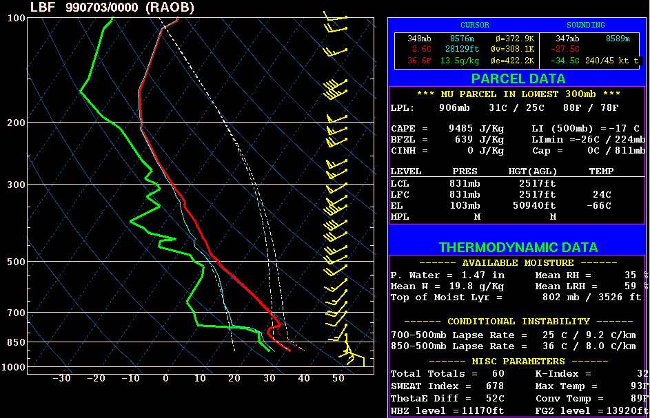
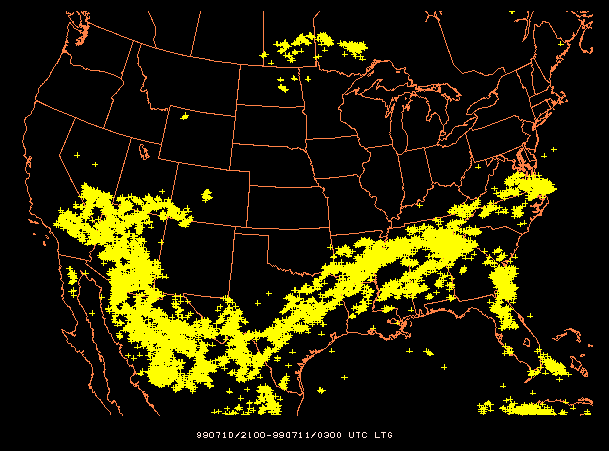
No comments:
Post a Comment